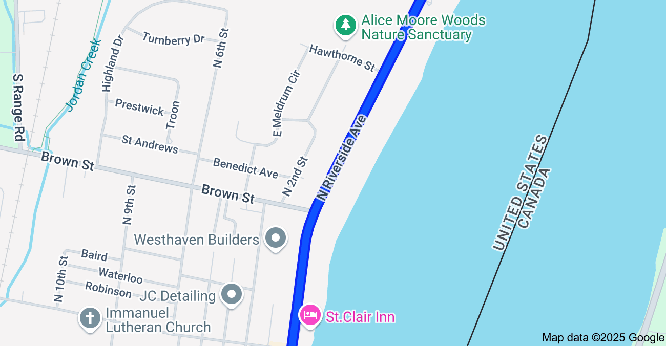
Riverside Avenue is a major north-south artery in the city of Saint Clair, Michigan, running parallel to the St. Clair River 1. While it provides scenic views and access to local businesses, residents have expressed concerns about traffic conditions on this vital roadway. This article investigates these concerns, exploring potential causes and solutions.
Traffic Studies and Data
Saint Clair, MI offers resources to monitor road conditions and traffic updates with a live interactive map including flow, delays, accidents, traffic jams, construction, and closures 2. Similarly, Saint Clair Township provides road conditions and traffic updates with a live interactive map including flow, delays, accidents, traffic jams, construction, and closures 3.
The Southeast Michigan Council of Governments (SEMCOG) offers an interactive map displaying traffic volumes across the region 4. While this resource doesn’t isolate Riverside Avenue, it helps visualize overall traffic patterns in St. Clair County, which can indirectly inform an understanding of traffic flow on Riverside Avenue. Additionally, SEMCOG provides crash and road data 5 that can be further analyzed to identify potential accident hotspots in the area, including Riverside Avenue.
Waze, a community-based traffic and navigation app, provides real-time traffic conditions on N Riverside Ave 1. This live map offers specific information about traffic flow, delays, and incidents on Riverside Avenue, directly addressing the article’s focus.
The Michigan Department of Transportation (MDOT) maintains a comprehensive database of traffic studies 7 and an interactive map with real-time traffic information, including incidents and construction 8. Although these resources don’t specifically focus on Riverside Avenue, they offer valuable context for understanding traffic management strategies and potential issues in the broader region.
The Marine City Highway Corridor Study 9 provides valuable insights into traffic flow and potential issues in the broader region, including areas near Riverside Avenue. This study examines traffic patterns and potential improvements along the Marine City Highway corridor, which includes portions of M-29 and stretches near Riverside Avenue.
Accident Reports and Congestion
While detailed accident statistics for Riverside Avenue are limited, some sources suggest potential concerns. The MDOT interactive map 10 shows a single-vehicle crash on westbound I-94 at Wadhams, which intersects with Riverside Avenue. This incident highlights the potential for accidents and traffic disruptions in the vicinity of Riverside Avenue. Traffic cameras monitor I-94, which intersects with Riverside Avenue 11. These cameras provide real-time monitoring of traffic conditions and can help identify potential accidents or congestion in the area.
A news report from ClickOnDetroit 12 mentions a fatal crash involving a car and a motorcycle in nearby China Township. While not directly on Riverside Avenue, this incident underscores the importance of road safety in the area and the potential for accidents on similar roadways.
Furthermore, a news article from FOX 2 Detroit 13 describes an incident where a St. Clair councilman, allegedly intoxicated, crashed into another car while leaving the parking lot of his restaurant on South Riverside Avenue. This incident raises concerns about driver behavior and the potential for accidents related to impaired driving on Riverside Avenue.
The Gateway Traveler Information System defines a major construction closure as one that involves multiple lane closures on an expressway or major arterial during the daytime, all lane closures during the evening, or all lane closures on a ramp from an expressway or major arterial to another expressway or major arterial 14. This information provides context for understanding the significance of traffic incidents and closures in the region.
Impact of Local Businesses
The presence of businesses along Riverside Avenue can contribute to increased traffic, particularly during peak hours or special events 13. For example, the incident involving the St. Clair councilman occurred as he was leaving the parking lot of his restaurant on South Riverside Avenue. This suggests that traffic concerns on Riverside Avenue may be exacerbated by the influx of customers or visitors to local businesses.
Driver Behavior and Road Safety
Several incidents highlight the need for increased driver awareness and responsible driving behavior on Riverside Avenue 10. The incident involving the allegedly intoxicated councilman underscores the risks associated with impaired driving. Additionally, the fatal crash in nearby China Township emphasizes the importance of safe driving practices on roadways similar to Riverside Avenue. Promoting responsible driving behavior, such as adhering to speed limits and avoiding distractions, is crucial for mitigating traffic concerns and ensuring road safety.
Traffic Calming Measures
While no specific traffic calming measures implemented on Riverside Avenue were found, exploring potential solutions is crucial. Traffic calming programs aim to increase the quality of life, create safer and more attractive streets, reduce the negative impacts of motor vehicles, and promote alternative transportation modes 17. Their objectives include achieving slower speeds for motor vehicles in residential areas, increasing safety for non-motorized users, enhancing the street environment, increasing access for all modes of transportation, and reducing or eliminating cut-through motor vehicle traffic.
Some common traffic calming strategies include:
| Traffic Calming Measure | Description | Potential Benefits |
|---|---|---|
| Speed humps | Physical barriers that encourage drivers to reduce their speed. | Reduced speeding, increased pedestrian safety. |
| Bulb-outs | Curb extensions that narrow the roadway and shorten pedestrian crossing distances. | Enhanced pedestrian safety, improved traffic flow. |
| Traffic circles | Roundabouts that facilitate smoother traffic flow and reduce conflict points. | Reduced congestion, improved safety. |
| Pavement markings | Visual cues, such as lane markings and crosswalks, that guide drivers and pedestrians. | Increased awareness, improved safety. |
| Reduced speed limits | Lowering the speed limit to encourage safer driving speeds. | Reduced speeding, increased safety. |
Examples of traffic calming measures implemented in Kalamazoo include speed tables, mini traffic circles, and speed humps in various neighborhoods 18. These examples demonstrate how traffic calming strategies can be applied in a similar context and offer potential solutions for Riverside Avenue.
Implementing appropriate traffic calming measures on Riverside Avenue requires careful consideration of the specific concerns, traffic patterns, and road characteristics 17. Collaboration between residents, local authorities, and traffic engineers is essential to develop effective solutions.
Synthesis and Conclusion
Based on the available information, traffic concerns on Riverside Avenue in Saint Clair, MI, primarily revolve around potential accidents, pedestrian safety, and driver behavior. While specific traffic studies and data focused solely on Riverside Avenue are limited, regional resources and resident feedback provide valuable insights.
Addressing these concerns requires a multi-faceted approach that may include:
- Conducting a comprehensive traffic study: Gathering detailed data on traffic volume, speed, and accident patterns to identify specific problem areas and inform potential solutions.
- Implementing traffic calming measures: Installing speed humps near Palmer Park and the St. Clair Middle School, bulb-outs at intersections with high pedestrian traffic, or other traffic calming devices to reduce speeds and enhance pedestrian safety.
- Increasing police presence: Enhancing traffic enforcement, particularly during peak hours and near local businesses, to deter speeding and reckless driving.
- Improving road infrastructure: Enhancing visibility with improved street lighting, adding signage to alert drivers of pedestrian crossings, and installing pedestrian crossings with flashing beacons to create a safer environment for all road users.
- Encouraging community involvement: Engaging residents in discussions through community forums or online platforms and seeking their input on potential solutions. The St. Clair County Road Commission website 5 provides contact information for reporting road concerns and obtaining information about road projects, offering a channel for residents to voice their concerns and potentially initiate further investigation or action.
By proactively addressing these concerns and fostering collaboration between residents and local authorities, Saint Clair can ensure that Riverside Avenue remains a safe and efficient roadway for all users.
Works cited
1. Driving directions, live traffic & road conditions updates – Waze, accessed January 26, 2025, https://www.waze.com/ka/live-map/directions?from=place.w.181862828.1818693819.4709004
2. Saint Clair, MI Road Conditions with Driving and Traffic Flow – LocalConditions.com, accessed January 26, 2025, https://www.localconditions.com/weather-saint-clair-michigan/48079/traffic.php
3. Saint Clair Township Road Conditions with Driving and Traffic Flow – LocalConditions.com, accessed January 26, 2025, https://www.localconditions.com/weather-saint-clair-township-michigan/mi304/traffic.php
4. SEMCOG Traffic Volume, accessed January 26, 2025, https://maps.semcog.org/trafficvolume/
5. St. Clair County Transportation Study (SCCOTS), accessed January 26, 2025, https://legacy.stclaircounty.org/offices/metro/SCCOTS.aspx
6. Driving directions, live traffic & road conditions updates – Waze, accessed January 26, 2025, https://www.waze.com/nl-BE/live-map/directions?from=place.w.181862828.1818693819.4709004
7. MDOT Traffic Study Summary – State of Michigan, accessed January 26, 2025, https://www.michigan.gov/mdot/-/media/Project/Websites/MDOT/Travel/Safety/MDOT-Traffic-Study-Summary.xlsx?rev=e1fb990f28cf4117928878726dc77e1b&hash=E5FCD7DA29F5D81AA0C9A6DB98B797D9
8. Mi Drive Map – MDOT, accessed January 26, 2025, https://mdotjboss.state.mi.us/MiDrive/map
9. Marine City Highway Corridor Study – St. Clair County, accessed January 26, 2025, https://www.stclaircounty.org/Uploads/Metro%20Planning/Marine%20City%20Hwy%20Corridor%20Study%20Final%20Report.pdf
10. Mi Drive Incidents – MDOT, accessed January 26, 2025, https://mdotjboss.state.mi.us/MiDrive/incident
11. Saint Clair, MI Live Traffic Cameras & Local Road Conditions | WeatherBug, accessed January 26, 2025, https://www.weatherbug.com/traffic-cam/saint-clair-mi-48079
12. St. Clair County – ClickOnDetroit, accessed January 26, 2025, https://www.clickondetroit.com/topic/St._Clair_County/
13. St. Clair councilman crashed into disabled man after leaving restaurant drunk | FOX 2 Detroit, accessed January 26, 2025, https://www.fox2detroit.com/news/st-clair-councilman-drove-drunk-struck-disabled-man-and-damaged-victims-car
14. Truckers Report – Travel Midwest, accessed January 26, 2025, https://travelmidwest.com/lmiga/truckersReport.jsp
15. St. Clair, Michigan – MSU College of Agriculture and Natural Resources, accessed January 26, 2025, https://www.canr.msu.edu/tourism_first_impressions/uploads/files/FIT2019-St.Clair%20Final%20Draft%20(1).pdf
16. Chapter 58 – TRAFFIC AND VEHICLES | Code of Ordinances | St. Clair (St. Clair Co.), MI, accessed January 26, 2025, https://library.municode.com/mi/st._clair_(st._clair_co.)/codes/code_of_ordinances?nodeId=CH58TRVE_ARTVIIIBI_S58-209PAGUNOPEVIARCH
17. Traffic Calming Program – City of Grand Rapids, accessed January 26, 2025, https://www.grandrapidsmi.gov/Government/Departments/Mobile-GR/Traffic-Calming-Program
18. Traffic Calming (Safe Streets for All) – City of Kalamazoo, accessed January 26, 2025, https://www.kalamazoocity.org/Community/Projects/2023/Planning/Traffic-Calming-Safe-Streets-for-All
19. Contact Us – St. Clair County Road Commission, accessed January 26, 2025, https://sccrc-roads.org/contact/


I need to find out more about S. Riverside. People drive like maniacs through the neighborhoods that way.